Products: EnterVol Product Suite
EnterVol provides true 3D volumetric modeling in the ArcGIS® Desktop environment. The EnterVol Suite consists of 4 components which are installed as extensions in ArcMap and ArcScene. EnterVol provides high level volumetric modeling that was previously not available except in our own Earth Volumetric Studio. EnterVol uses the same proven technology in C Tech's EVS & EVS Advanced software used worldwide by customers such as the U.S. Environmental Protection Agency, Environment Canada, Chinese Research Academy of Environmental Sciences, U.S. Geological Survey, British Geological Survey, U.S. Army Corps of Engineers, U.S. Department of Energy Laboratories, United Nations, and the majority of the world's largest engineering and environmental consulting firms.
GIS centric organizations can now address all of their modeling needs within the familiar ArcGIS® Desktop environment. The EnterVol Suite is priced from $6,000.
Explore why just displaying surfaces in 3D isn’t enough…
EnterVol Product Suite Details

EnterVol Volume Analyst© is the analysis and visualization component of the EnterVol product suite.. It imports volumetric geology and/or analyte models created in EVS or models created with EnterVol GeoStats© or EnterVol Geology© components. It will perform subsetting (plumes, cuts, slices, cross-sections, contouring, etc.) and analysis (volumetrics) inside of ArcGIS. 3D visualization of these models is performed using ArcSceneTM. Priced from $2,500

EnterVol GeoStats© adds true volumetric model creation with analyte (e.g. chemistry, ore data) and topography data making full 3D Volumetric Modeling in ArcGIS Desktop a reality. Using the same technology in C Tech's EVS & MVS software, our expert systems will guide you through the process of performing 2D and 3D volumetric estimation using Kriging and inverse distance weighted. Requires EnterVol Volume Analyst©. Priced from $1,750

EnterVol Geology© builds complex geologic models based on stratigraphy and/or lithology data. EnterVol Geology's Smooth Lithologic modeling is unlike anything you've ever seen. When used with EnterVol GeoStats©, analyte data can be mapped into the true volumetric geologic models. Requires EnterVol Volume Analyst©. Priced from $2,750
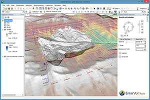
EnterVol Tools© provides several fundamental capabilities to ArcMap and ArcScene users including building closed multi-patches (pseudo volumes) from two rasters of arbitrary resolution or extent, enhanced view controls, labeled axes, data labeling, direction indicator(s) and more. This product is included with all components of the EnterVol Suite, but is also available separately from $299.